Turkey: 6 Hidden Gems You Need to Discover
From the Aegean to the Dardanelles, Lake Van, the Black Sea, Safranbolu, and the Turkish Lakes Region, Turkey hides six unforgettable stops: Bodrum, Çanakkale, Akdamar Island, Amasya, Safranbolu, and Lake Salda—the "Turkish Maldives" with white sands and turquoise water. Discover why each deserves a place on your Turkish itinerary.
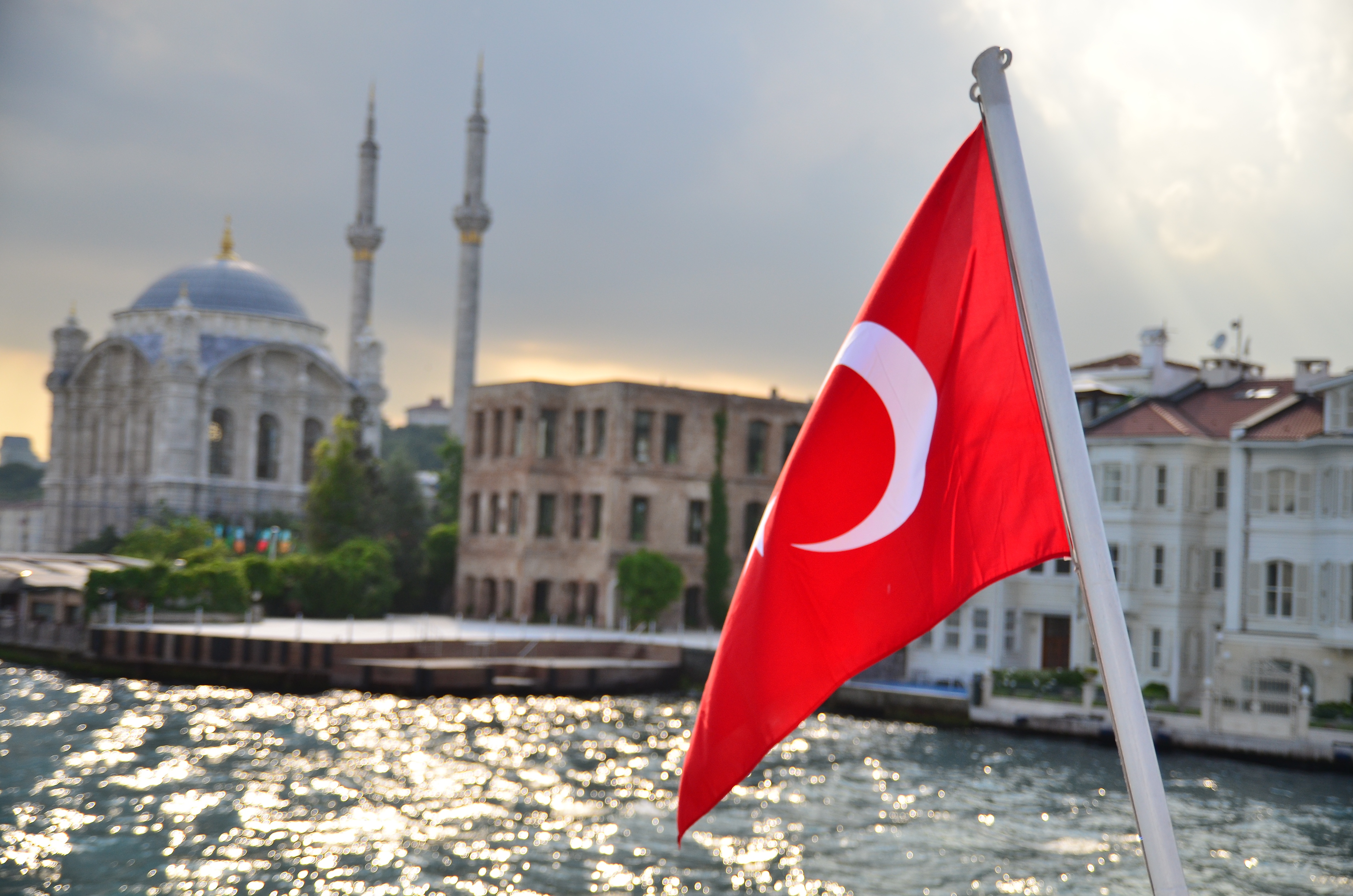
Turkey's coasts are dotted with towns where ancient history meets the sea. On the Aegean, Bodrum carries the legacy of the Mausoleum of Halicarnassus and a Crusader castle; on the Dardanelles, Çanakkale is the gateway to Troy and the Gallipoli battlefields. Both reward travelers who look beyond Istanbul and the big resorts.
Bodrum
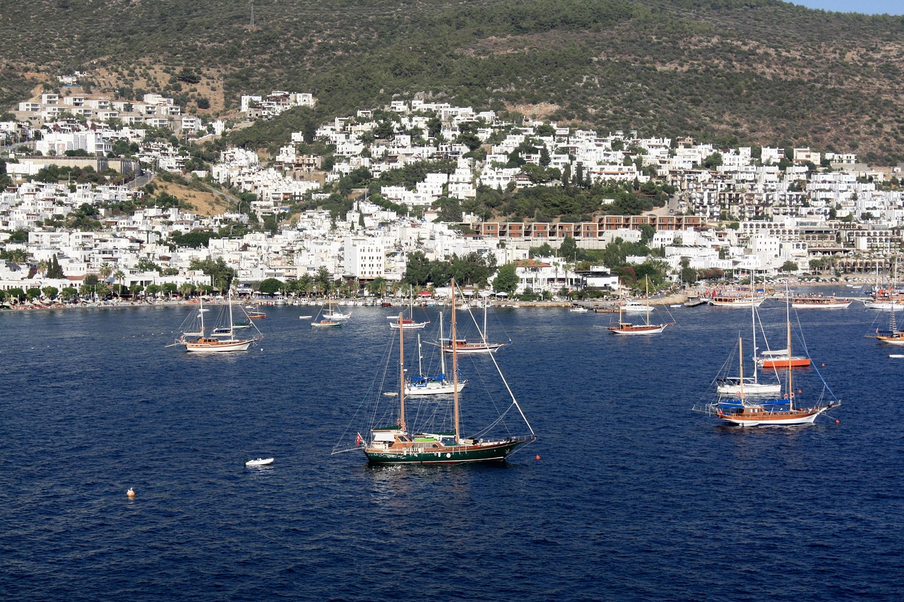
Bodrum sits on the southwest coast of Turkey in Muğla Province, where the Mediterranean meets the Aegean. In ancient times it was known as Halicarnassus, founded by Dorian Greeks and later the capital of Caria under the Persians. The Mausoleum at Halicarnassus—the tomb built for Mausolus in the 4th century BC—was one of the Seven Wonders of the Ancient World. Today only foundations and fragments remain; the Knights Hospitaller used the ruins as a quarry to build Bodrum Castle (Castle of St. Peter) in the 15th century. The castle still dominates the harbour and houses the Bodrum Museum of Underwater Archaeology, with finds from ancient shipwrecks in the Aegean. The town's name is thought to derive from Petronium, linked to the Castle of St. Peter.
Getting to Bodrum is straightforward: Milas–Bodrum Airport and Kos International Airport serve the area, and ferries connect the port to Kos and other Greek and Turkish islands. Bodrum is often called the yacht capital of Turkey—the marina is full of boats of all sizes, and the waterfront promenade is ideal for a stroll. The 15th-century castle is the main sight: it retains its Gothic character, with peacocks on the grounds and views over the sea. Tickets can be bought on the spot. The old town offers narrow streets, seafood restaurants, and the chance to watch craftsmen making blown-glass evil eye pendants in the night market. For a different vibe, the seaside village of Gümüşlük is perfect for lunch, while Yalikavak Marina on the other side of the peninsula offers upscale dining and shopping. Renting a car (around 30 minutes between the two sides) makes it easy to explore beaches and bays.
Bodrum has a hot-summer Mediterranean climate—winters are mild (around 15 °C), summers hot and sunny (around 34 °C). Tourism has replaced fishing as the main industry, but the town still feels like a real place rather than a resort strip. Whether you stay in Bodrum town near the castle and marina or at a quieter resort along the coast, you get a mix of history, sea views, and Turkish hospitality.
Canakkale
Çanakkale is a city and seaport on the southern shore of the Dardanelles at their narrowest point. It is the seat of Çanakkale Province and the main base for visiting the ruins of Troy and the First World War cemeteries at Gallipoli. The name means "Pottery Castle" (Çanak Kalesi): from the late 17th century the town was known for its glazed ceramics, and the Ottoman fortress Kale-i Sultaniye—built by Mehmed the Conqueror in 1462—stood here with Kilitbahir Castle on the opposite shore to control traffic through the strait. Today the old fortress is Çimenlik Castle, open as a military and naval museum with a replica of the minelayer Nusret; the waterfront is lined with cafés and the wooden Trojan Horse from the 2004 film Troy, donated to the city by Warner Brothers.
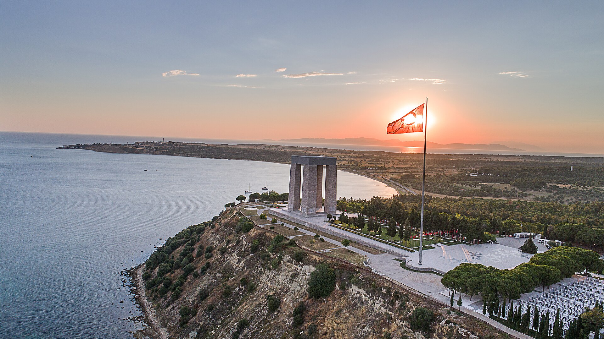
Çanakkale Airport is about 3 km from the centre, with domestic flights from Istanbul and Ankara; intercity buses run to Bursa, Istanbul, and İzmir. The 19th-century clock tower (1896) marks the old part of town, where narrow streets lead to the City Museum (Kent Müzesi) and the Rhapsodos Mozaik—a mosaic exhibition that tells the story of Troy. A combined ticket for the Troy archaeological site and the Museum of Troy (about 32 km southwest) is around 80 TL; minibuses (dolmuş) to Troy/Tevfikiye leave from under the bridge on Atatürk Caddesi several times a day for about 10 TL one way. Ferries cross to Kilitbahir (where Kilitbahir Castle can be visited for about 20 TL) and to Eceabat on the Gallipoli peninsula—where the Battle of Gallipoli is commemorated and Suvla Winery offers tastings. The 1915 Çanakkale Bridge now links the two sides of the strait for those driving.
Around 18 March and 25 April (Anzac Day) the town is especially busy with ceremonies. The rest of the year Çanakkale keeps a relaxed, small-town feel: mornings by the water with a simit and coffee, evenings along the waterfront with views of ships passing through the Dardanelles. It is the perfect base for Troy, Gallipoli, and the Biga Peninsula—a hidden gem where myth, history, and the sea meet.
Akdamar Island
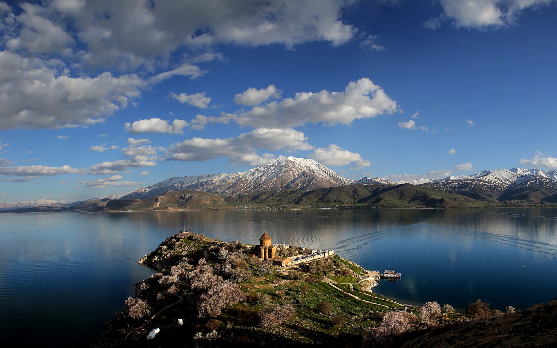
Akdamar Island (Akdamar Adası) is the second largest of the four main islands in Lake Van, in eastern Turkey. It lies in Van Province, near the southern shore, about 3 km from the coast and covers roughly 0.7 km². At the western end a limestone cliff rises about 80 m above the lake; the island slopes to the east where a spring provides water. It is home to the 10th-century Armenian Cathedral of the Holy Cross (Surp Khach), built of pink volcanic tuff by the architect-monk Manuel between 915 and 921 for King Gagik I Artsruni of the Kingdom of Vaspurakan. The church was the seat of the Catholicosate of Aghtamar from 1116 to 1895. A folk legend gives the island its name: a princess named Tamara lit a lantern so her lover could swim to her each night; when her father extinguished it, the boy drowned and his last words—"Akh, Tamar" (Oh, Tamara)—are said to have become "Akdamar." The Turkish name is sometimes interpreted as "white vein."
Reach the island by boat from Akdamar Pier (Akdamar İskelesi) near the town of Gevaş. Minibuses run from Van (about 45 minutes) or Tatvan (about 90 minutes) to Gevaş; having a car is more convenient. Round-trip ferry rides cost around 200 TL per person; boats leave when there are enough passengers and the crossing takes about 20 minutes. Admission for foreign visitors is around €12; the site is open as the Akdamar Monument Museum (Akdamar Anıt Müzesi). The cathedral was restored between 2005 and 2006 and reopened in March 2007; a cross was placed on the dome again in October 2010, and an annual Divine Liturgy has been held since then. Allow time to see the rich stone reliefs on the exterior—biblical scenes, saints, and secular figures—and the ruins of the monastic complex. A path leads to an observation deck with views over Lake Van and, in the distance, Mount Süphan. There is a small café and gift shop on the island.
Lake Van does not freeze even in cold weather and is one of Turkey's largest lakes. Akdamar is a hidden gem of eastern Turkey: a place where Armenian medieval art, a touching legend, and the deep blue of the lake come together far from the crowded coast.
Amasya
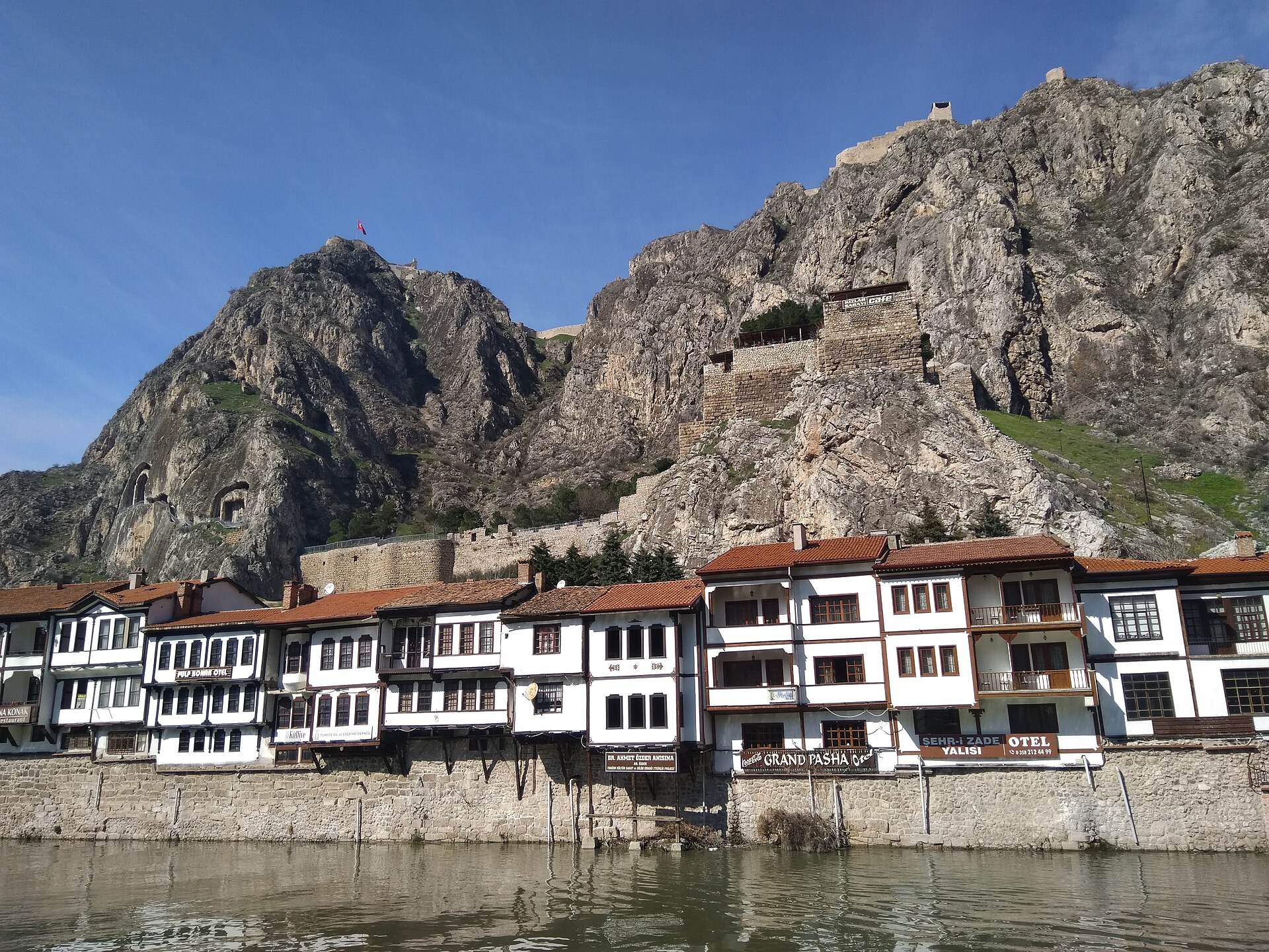
Amasya is a city in northern Turkey, in the Black Sea region, set in a narrow valley along the banks of the Yeşilırmak (Green River). With a history of about 7,500 years, it was known in antiquity as Amaseia and was the capital of the Kingdom of Pontus from the 4th century BC. The geographer Strabo was born here; in Ottoman times young princes were sent to Amasya to govern and gain experience, and the sultans Murad I and Selim I were born in the city. The most striking sight is the row of royal tombs of the Pontic kings carved into the cliffs high above the river—five dramatic rock-cut façades dating to the 3rd century BC, with walkways and tunnels making them accessible. Below, traditional Ottoman wooden houses (Yalıboyu) line the west bank, many restored as boutique hotels, cafés, and restaurants. Amasya province is famed for its apples; the area has an inland climate well suited to orchards despite being in the mountains above the Black Sea coast.
Reach Amasya by intercity bus from Istanbul, Ankara, Samsun, or other cities; the nearest airport is at Merzifon (Turkish Airlines), with Samsun airport about 150 km away. Entry to the Tombs of the Kings of Pontus (Pontus Kralları Mezarları) is around 10–25 TL; Harshena Castle (Harşena Kalesi) on the mountaintop above—about 280 m above the city and in use since Hittite times—costs around 10 TL. The Beyazid II complex (1486), with its mosque, madrasah, and shadirvan, is free to visit, as is the Roman "Low" Bridge (Alçak Köprüsü) over the Yeşilırmak. The 13th-century Birmahane (Seljuk hospital, now a medical museum) and the Archaeology Museum (with mummified Ilkhanid remains and Hittite finds) are also worth a visit. Stroll the riverfront by day and again at night when the houses, tombs, and castle are lit up. In 1919 Mustafa Kemal Atatürk issued the Amasya Circular here, a key step toward the Turkish War of Independence.
Amasya is a hidden gem of the Black Sea region: few places in Turkey pack so much history—Pontic, Roman, Byzantine, Seljuk, and Ottoman—into such a photogenic valley, with the river, the wooden houses, and the cliff tombs forming one of the country's most memorable townscapes.
Safranbolu
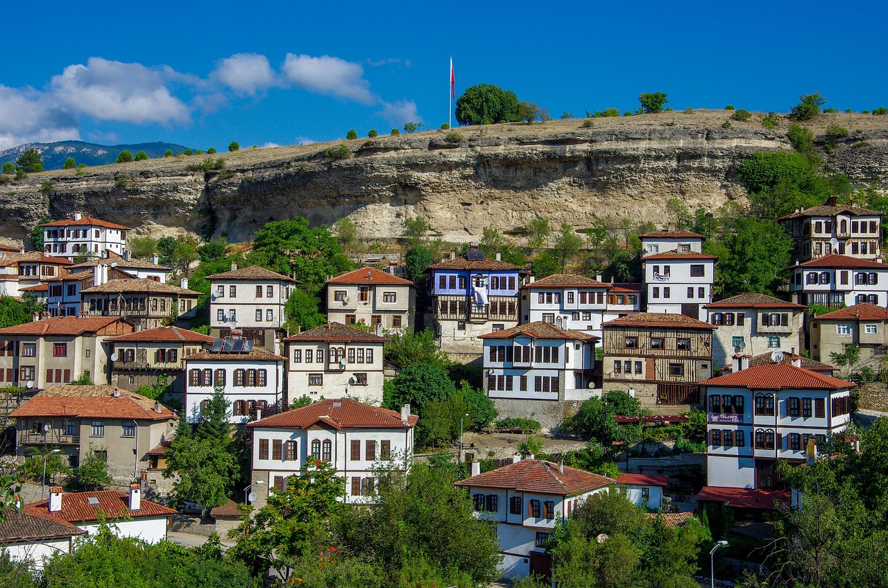
Safranbolu is a town in Karabük Province in the Black Sea region of Turkey, about 9 km north of Karabük, 200 km north of Ankara, and roughly 100 km south of the Black Sea coast. Its name comes from saffron (safran) and the Greek word for city (polis): it was a trading place and centre for growing saffron, and saffron is still cultivated at the village of Davutobası, 22 km to the east. In 1994 the Old Town was inscribed as a UNESCO World Heritage site for its well-preserved Ottoman-era houses and architecture. The historic centre sits in a deep ravine; the New Town spreads on the plateau about 2 km west. The Old Town has over 1,000 registered historic elements—hundreds of wooden houses and mansions, 25 mosques, 5 tombs, 8 fountains, 5 Turkish baths, 3 caravanserais, a clock tower, and a sundial—making it one of Turkey's best-preserved Ottoman townscapes.
Reach Safranbolu by intercity bus from Ankara, Istanbul, or the coast; the town is well connected by road. Wander the narrow cobblestone streets of the Old Town, where Ottoman houses with wooden balconies, large windows, and slate roofs line the slopes—many now boutique hotels, cafés, and restaurants. Must-sees include the Kaymakamlar Mansion (19th century), now a museum; the Cinci Han, a stone caravanserai that once lodged travellers and now houses shops and restaurants; and the 17th-century Cinci Hamam (Turkish bath). The Köprülü Mehmet Paşa complex (mosque, madrasah, mausoleum) and the Old Bazaar (Çarşı) area are also worth a visit. In the evening, climb to a café on the plateau for views over the lit-up Ottoman houses and minarets. Spring and autumn are ideal for exploring; the town is pleasant in summer and cozy in winter.
Safranbolu was an important stop on the caravan route and pilgrimage route in Ottoman times; wealthy merchants built the mansions that give the town its character. Today it is a hidden gem for anyone who wants to step into an almost intact Ottoman town, sip çay in a centuries-old house, and discover why UNESCO recognised it as a masterpiece of vernacular architecture.
Lake Salda
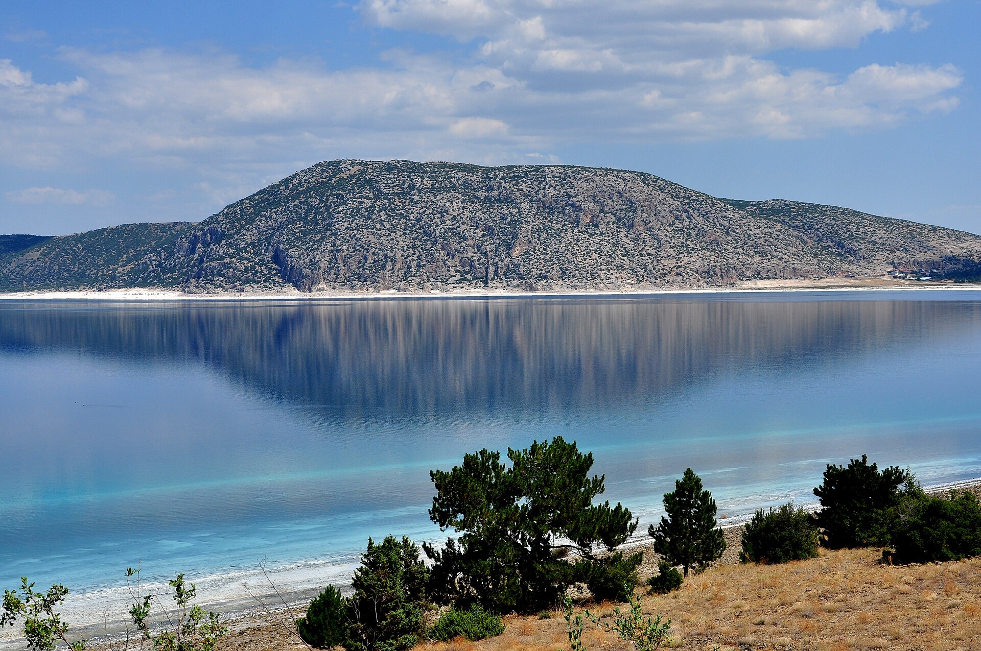
Lake Salda (Salda Gölü) is a crater lake in southwestern Turkey, in Yeşilova district of Burdur Province, about 50 km west of the city of Burdur. With a surface area of roughly 44 km² and a maximum depth of 196 m, it is one of the deepest lakes in Turkey and sits at an elevation of about 1,316 m. The lake is famous for its white sandy beaches, turquoise water, and seven small crystal-white islets—a combination that has earned it the nickname "Turkey's Maldives" or "Saldives." The striking colour comes from hydromagnesite mineral in the water, which is also thought to have beneficial effects for some skin conditions; the same mineral gives the shore its bright white colour. The lake is alkaline and is one of the few places on Earth where living stromatolite algae still form—rock-like structures built by microbes. NASA has studied Lake Salda's microbialites because they are the closest match on Earth to minerals found in Mars's Jezero Crater, where the Perseverance rover searches for signs of ancient life.
Reach Lake Salda by car from Burdur, Denizli, or Fethiye (about 2.5 hours from Fethiye); the village of Salda lies at the southwestern shore and Yeşilova about 4 km to the east. Yeşilova manages camping and facilities; the Halk Plajı (public beach) on the Yeşilova side has camping, wooden bungalows, and snack bars. The Salda village side is quieter and more dramatic for photos. Because of the altitude, temperatures are several degrees cooler than on the coast—bring layers in spring and autumn. Swimming is possible in the shallows (the deep centre is cold and only safe for experienced swimmers); in summer the shallow water warms up. Visit out of season or on weekdays for fewer crowds. The area is protected; respect the environment and use designated bins. Snack bars along the beach serve gözleme, köfte, and the local Burdur speciality kıymalı tost.
Lake Salda is a hidden gem of the Turkish Lakes Region: other-worldly white shores, turquoise water, and the chance to see a landscape that has drawn scientists and travellers alike—whether for its beauty or its link to the search for life on Mars.
Spirit of Traveling Team
Passionate traveler and content creator sharing authentic travel experiences and practical tips for independent explorers.