United States: 10 Hidden Gems You Need to Discover
Beyond the famous national parks and big cities, America holds extraordinary and lesser-visited treasures. Big Bend in West Texas, John Day Fossil Beds in Oregon, Lassen Volcanic in California, Custer State Park in South Dakota's Black Hills, the Adirondack Mountains in upstate New York, the Apostle Islands in Lake Superior, Ocracoke Island in North Carolina's Outer Banks, Marfa in the Texas high desert, Cumberland Island National Seashore off Georgia's coast, and Canyons of the Ancients National Monument in southwestern Colorado. Each rewards those willing to make the journey.

When most travelers think of the United States, images of New York City, the Grand Canyon, or California's coast come to mind. But from remote West Texas to east-central Oregon to northeastern California to South Dakota's Black Hills to upstate New York to northern Wisconsin's Lake Superior shore to North Carolina's Outer Banks to the high desert of West Texas to Georgia's Golden Isles to southwestern Colorado's Four Corners, the country holds extraordinary and lesser-visited treasures. Big Bend National Park, John Day Fossil Beds National Monument, Lassen Volcanic National Park, Custer State Park, the Adirondack Mountains, the Apostle Islands, Ocracoke Island, Marfa, Cumberland Island National Seashore, and Canyons of the Ancients National Monument are ten hidden gems that reward those willing to make the journey.
Big Bend National Park
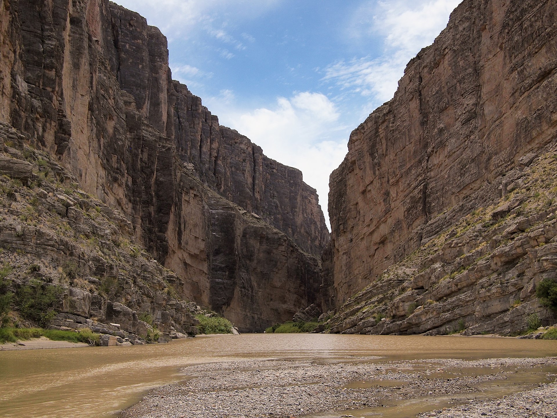
Big Bend National Park is the largest protected area of Chihuahuan Desert in the United States, encompassing over 800,000 acres in Brewster County, Texas. Named after a large bend in the Rio Grande, it was established in 1944 and protects a vast diversity of plants and wildlife. The Chisos Mountains rise within the park, the only range fully inside a national park boundary, with Emory Peak reaching 7,832 feet (2,387 m). Big Bend remains one of the most remote and least-visited national parks in the contiguous United States, offering a sense of solitude that is increasingly rare.
Getting there requires planning. The park is in an unincorporated area of Brewster County; the nearest city is Alpine, Texas. The closest major airport is Midland-Odessa, about a four-hour drive from the park entrance. Once inside, the park is huge—allow at least two to three days to experience key areas. The 30-mile (48 km) Ross Maxwell Scenic Drive leads to Santa Elena Canyon and the Castolon Historic District; Chisos Basin Road climbs 6 miles to 5,679 feet (1,731 m) at Panther Pass. Five paved roads serve the park; for gravel routes such as Old Maverick Road or Dagger Flats Auto Trail, an SUV with ground clearance is recommended. Fill up with gas and bring plenty of water—services are limited.
The star attraction is Santa Elena Canyon, where the Rio Grande cuts through spectacular limestone walls. The 1.8-mile round-trip trail is not difficult but is steep in places; the views are worth the effort. At the river you can wade along the canyon between the towering walls. Other highlights include Boquillas Canyon on the eastern side, the Mule Ears—two imposing rock towers in the desert—Grapevine Hills and Balanced Rock, and the Hot Springs Historic District, where J.O. Langford began developing the springs in 1909. The park administers 118 miles (190 km) of the Rio Grande for recreation; professional outfitters provide river tours. In April 2013 the Boquillas border crossing reopened; visitors can cross to the Mexican village of Boquillas (Wednesday through Sunday, 9 am to 6 pm; bring a passport). In 2012 Big Bend was designated an International Dark-Sky Park with Gold Tier designation—it has the darkest measured skies in the contiguous United States, perfect for stargazing.
The best time to visit is spring—when wildflowers and cacti are in bloom, especially in late April—or fall; summer temperatures in lower elevations often exceed 100 °F (38 °C). The Fossil Discovery Exhibit is a great stop for families. Lodging options include the Chisos Basin campground and lodge inside the park, or nearby Terlingua, Lajitas, and Alpine; the historic Holland Hotel in Alpine makes a convenient base. Arrive early at the Starlight Theatre in Terlingua Ghost Town for dinner. Big Bend captivates with dramatic desert, river canyons, mountain sky islands, and night skies that few places in the country can match.
John Day Fossil Beds National Monument

John Day Fossil Beds National Monument is a U.S. national monument in Wheeler and Grant counties in east-central Oregon, managed by the National Park Service. The park is known for its well-preserved layers of fossil plants and mammals that lived in the region between the late Eocene, about 45 million years ago, and the late Miocene, about 5 million years ago. The monument consists of three geographically separate units: Sheep Rock, Painted Hills, and Clarno, covering 14,062 acres (56.91 km²) of semi-desert shrublands, riparian zones, and colorful badlands. Established in 1975, it was named for the John Day River. The monument has three separate units: Sheep Rock, Painted Hills, and Clarno. Park headquarters and the main visitor center are in the Sheep Rock Unit, about 122 miles northeast of Bend. The units are spread out; allow a full day to see more than one. The Painted Hills Unit lies northwest of Mitchell; the Clarno Unit is west of Fossil; the Sheep Rock Unit is along the John Day River. Many visitors take U.S. 26 from Redmond toward John Day to see Painted Hills and Sheep Rock in a day.
The Thomas Condon Paleontology Center at the Sheep Rock Unit opened in 2005 and features fossil displays, murals depicting life in the basin across eight geologic periods, and views of the paleontology laboratory where fossils are prepared. The James Cant Ranch Historic District offers cultural history exhibits in the historic ranch house. The Painted Hills Unit is the star for many visitors—multicolored strata in shades of red, gold, and black create an otherworldly landscape. Short trails include the Painted Cove Trail at Painted Hills; Blue Basin (3 miles) and other trails at Sheep Rock; and three quarter-mile trails at the Clarno Unit below the dramatic Clarno Palisades. Entrance is free; trails, overlooks, and picnic sites are open during daylight hours year-round. No food, lodging, fuel, or camping is available in the park.
The best time to visit is spring or fall; summer highs near Mitchell average about 86 °F (30 °C). Stay on the trails and do not collect or disturb fossils. The Thomas Condon Paleontology Center is open daily from 10 a.m. to 5 p.m. except from Veterans Day through Presidents' Day in winter. John Day Fossil Beds rewards travelers who love geology, fossils, and landscapes that feel like another world.
Lassen Volcanic National Park
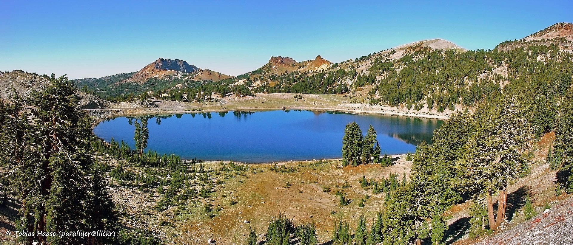
Lassen Volcanic National Park is a national park in northeastern California, in portions of Shasta, Lassen, Plumas, and Tehama counties. The dominant feature is Lassen Peak, the largest plug dome volcano in the world and the southernmost volcano in the Cascade Range, rising to 10,457 feet (3,187 m). The area is still active with boiling mud pots, fumaroles, and hot springs. The park was established in 1916 after eruptions from 1914 to 1917. With about 500,000 visitors per year, it offers mountain scenery reminiscent of Yosemite and thermal wonders similar to Yellowstone with far fewer crowds.
The park is approximately four hours northeast of San Francisco. The nearest cities are Redding and Susanville, California; the nearest airports are Redding, Sacramento, and Reno. The park is accessed via State Routes 89 and 44. The 29-mile (47 km) Main Park Road reaches 8,512 feet (2,594 m) near Lassen Peak, the highest road in the Cascade Mountains. It is not unusual for 40 feet (12 m) of snow to accumulate near Lake Helen, and patches of snow often last into July. The road through the park is typically closed in winter; the ideal time to visit is July through September when the road is open. Always check current conditions on the National Park Service website before planning your trip.
Start at the Kohm Yah-mah-nee Visitor Center near the southwest entrance—the name is the Mountain Maidu phrase for Lassen Peak, meaning "snow mountain." The star attraction is Bumpass Hell, the largest hydrothermal area in the park—a 3-mile round-trip trail leads to boardwalks above boiling mud pots and fumaroles; the largest fumarole, the Big Boiler, has been measured as high as 322 °F (161 °C). Lake Helen, set against Lassen Peak and Chaos Crags, is a stunning high-elevation lake that remains frozen much of the year. Other highlights include Kings Creek Falls (about 2.3 miles round trip), Sulphur Works (roaring fumaroles and boiling mud pots beside the road), Manzanita Lake (with reflections of Lassen Peak), Reflection Lake, and Cinder Cone with the Painted Dunes and Fantastic Lava Beds. The Loomis Museum near Manzanita Lake displays photographs of the 1915 eruption. Drakesbad Guest Ranch offers the only in-park lodging; camping is available at Manzanita Lake and Summit Lake. Vehicle entrance fee is $35; the park is open 24 hours a day, 365 days a year, though the through road is seasonal.
Note: The park was significantly affected by the Dixie Fire in August 2021; some areas and trails may have limited access or regrowth. Check the NPS website for current conditions. Lassen rewards travelers who love volcanic landscapes, alpine lakes, and hydrothermal wonders without the crowds of Yellowstone or Yosemite.
Custer State Park
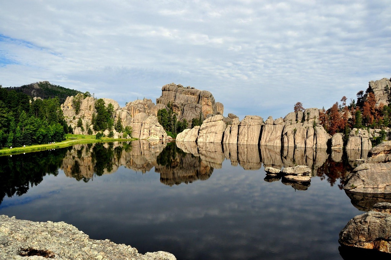
Custer State Park is South Dakota's first and largest state park, covering over 71,000 acres (287 km²) in the Black Hills of Custer County. Named after Lieutenant Colonel George Armstrong Custer, the park was established in 1912 and combines rolling prairie grasslands with rugged mountains. It is home to one of the country's largest publicly owned bison herds—about 1,500 animals—plus elk, pronghorn, bighorn sheep, mountain goats, prairie dogs, and the famous "begging burros," feral donkeys that often approach vehicles (do not feed them). Despite sitting in the shadow of Mount Rushmore, Custer State Park remains a hidden gem: wildlife, scenic drives, and alpine lakes draw return visitors who find it more intimate than the nearby national parks.
The park is easily accessible from Rapid City, about 30 miles southeast; the town of Custer lies just outside the western boundary. The 18-mile Wildlife Loop Road winds through open grassland where bison herds frequently cause "traffic jams"—allow plenty of time and keep a safe distance (bull bison can weigh up to 2,000 pounds). The Needles Highway (South Dakota Highway 87) and the Peter Norbeck Scenic Byway offer dramatic granite spires and tunnels. Sylvan Lake, in the park's northern section, is a must-see: surrounded by striking rock formations, it's the start of the Sunday Gulch Trail (about 4 miles round trip, with some technical sections and water crossings) and routes to Black Elk Peak—at 7,244 feet (2,208 m), the highest point in South Dakota—and the Cathedral Spires. The Peter Norbeck Visitor Center (on U.S. Route 16A) and the park's visitor center offer natural history exhibits and information; the annual bison roundup in late September draws thousands of spectators.
Lodging and camping are available inside the park (Custer State Park Resort, various campgrounds); nearby towns such as Custer, Hill City, and Hermosa offer additional options. Wind Cave National Park, Jewel Cave National Monument, Crazy Horse Memorial, and Badlands National Park are all within about an hour or two. A park entrance fee is required; check gfp.sd.gov for current rates and seasonal road closures. Custer State Park rewards travelers who love wildlife, scenic drives, and the Black Hills without the crowds of Mount Rushmore.
Adirondack Mountains
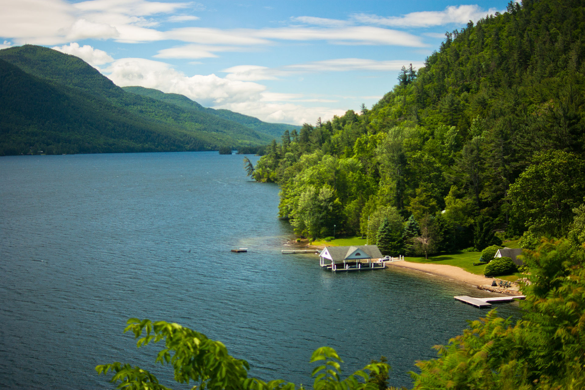
The Adirondack Mountains are a massif in northeastern New York forming a circular dome approximately 160 miles (260 km) wide and covering about 5,000 square miles (13,000 km²). Mount Marcy, at 5,344 feet (1,629 m), is the highest point in New York; the Adirondack High Peaks—a traditional list of 46 peaks over 4,000 feet (1,200 m)—draw hikers from across the Northeast. The region has over 200 named lakes, including Lake George, Lake Placid (host of the 1932 and 1980 Winter Olympics), and the source of the Hudson River. The entire region lies within Adirondack Park, over 6 million acres of state-protected land, larger than Yellowstone, Yosemite, Grand Canyon, Everglades, and Glacier combined. The Forever Wild clause keeps development off the forest preserve, so the mountains remain a hidden gem for hikers, paddlers, and skiers.
The park is accessible from Albany, Syracuse, Montreal, and New York City; Lake Placid, Saranac Lake (the "Capital of the Adirondacks"), Lake George village, and Keene are popular bases. Route 73 and the road to Adirondack Loj (near Heart Lake) are among the most scenic drives; the Loj is a gateway to the High Peaks and one of the few places where parking is paid. For a first High Peak, Cascade Mountain (7.7 km, about 4 hours round trip) is considered the easiest—arrive early in summer as lots fill. Indian Head (about 15.5 km, 4 to 5 hours) rewards with dramatic views over Lower Ausable Lake; stop at Rainbow Falls on the way. Mt. Jo is a short, easy hike with fine views over Heart Lake. Goodnow Mountain fire tower offers a relatively short climb and 360-degree views—popular at sunrise. Whiteface Mountain (4,867 ft) has the only ski resort with a lift-served summit in the East and belongs to the state; Lake Placid and Mirror Lake offer swimming, paddling, and the iconic Adirondack chair (invented in Westport in 1903). Camping is available at state campgrounds such as Sharp Bridge (about 23 USD for out-of-state); Keene has cafés and supplies. Check dec.ny.gov and visitadirondacks.com for trails, conditions, and seasonal access.
The best time to visit is late spring through fall for hiking and paddling; winter brings skiing, snowshoeing, and ice skating. Summer temperatures are cooler than the rest of New York (roughly 66 to 73 °F, 19 to 23 °C by day); evenings can be chilly. No park-wide entrance fee applies, but some parking areas and facilities charge. The Adirondack Mountains reward travelers who want big peaks, countless lakes, and a sense of wilderness within a few hours of the Northeast's cities.
Apostle Islands
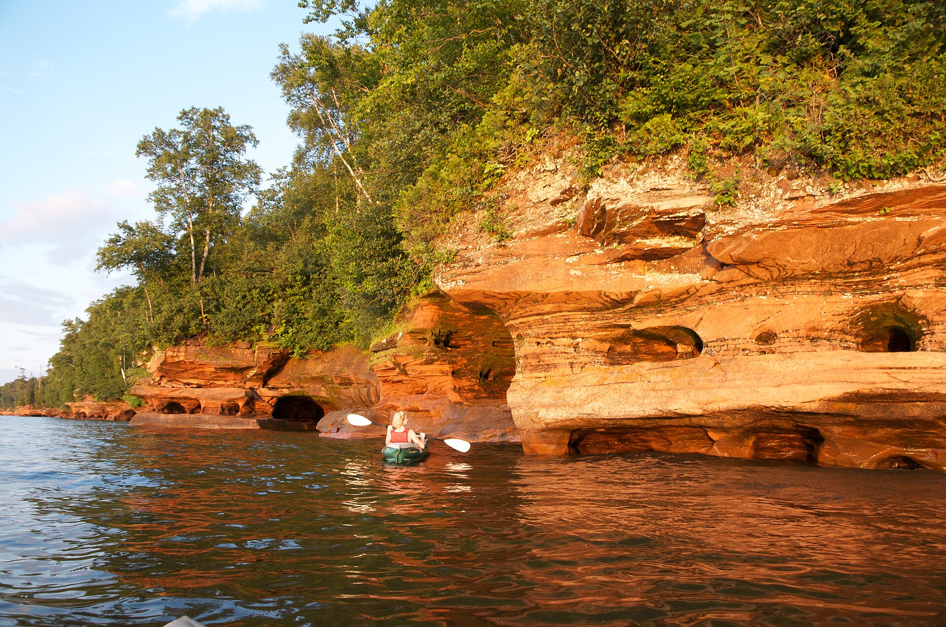
The Apostle Islands are a group of 22 islands in Lake Superior, off the Bayfield Peninsula in northern Wisconsin. The majority lie in Ashland County; Sand, York, Eagle, and Raspberry Islands are in Bayfield County. All except Madeline Island—the largest and only inhabited island—are part of Apostle Islands National Lakeshore. The region is dominated by boreal forest with over 800 plant species; Stockton Island has one of the greatest concentrations of black bears in North America. What makes the Apostles a hidden gem are the sea caves: delicate arches, vaulted chambers, and honeycombed passageways carved by waves and weather along the north shore of Devils Island, Sand Island, and the mainland near Meyers Beach. In winter, when the lake freezes, the Park Service sometimes allows visitors to walk from Meyers Beach across the ice to see frozen waterfalls and icicle-filled chambers—a rare Great Lakes experience.
Bayfield, on the mainland, is the main gateway: a small port town with lodging, restaurants, and the ferry to La Pointe on Madeline Island (about 20 minutes). Apostle Island Cruises offers boat tours (e.g. Grand Tour or Sea Caves and Lighthouses; adult tickets around $50); kayaking is the best way to get up close to the caves—Lost Creek Adventures, Whitecap Kayak, and others run half-day and full-day trips (from about $60 per person for a half-day). Lake Superior can turn rough quickly; only paddle if you are prepared and check conditions. On foot, the Meyers Beach Sea Caves Trail is a 4-mile round trip to the first cave overlooks (or 9 miles to the end of the trail) through boreal forest with cliff and lake views; parking at Meyers Beach is about $5 per day. Devils Island has the largest and most impressive caves but is 22 miles out—reachable by cruise or longer kayak expeditions. Six lighthouses dot the islands (Sand Island, Raspberry Island, Devils Island, Michigan Island, Outer Island, Gull Island); some cruises include lighthouse stops. Madeline Island has Big Bay State Park (about 6 miles from the ferry); rent a bike or bring a car on the ferry to explore. Summer and fall are ideal for paddling and hiking; winter offers ice caves when conditions allow. Check nps.gov/apis for current access, ice conditions, and tours.
The Apostle Islands were chosen as Wisconsin's America the Beautiful quarter in 2018. Lodging and dining are concentrated in Bayfield, Washburn, and Cornucopia; camping is available in the national lakeshore and on Madeline Island. The Apostle Islands reward travelers who love sea caves, lighthouses, kayaking, and a rugged Lake Superior coastline far from the usual national-park crowds.
Ocracoke Island
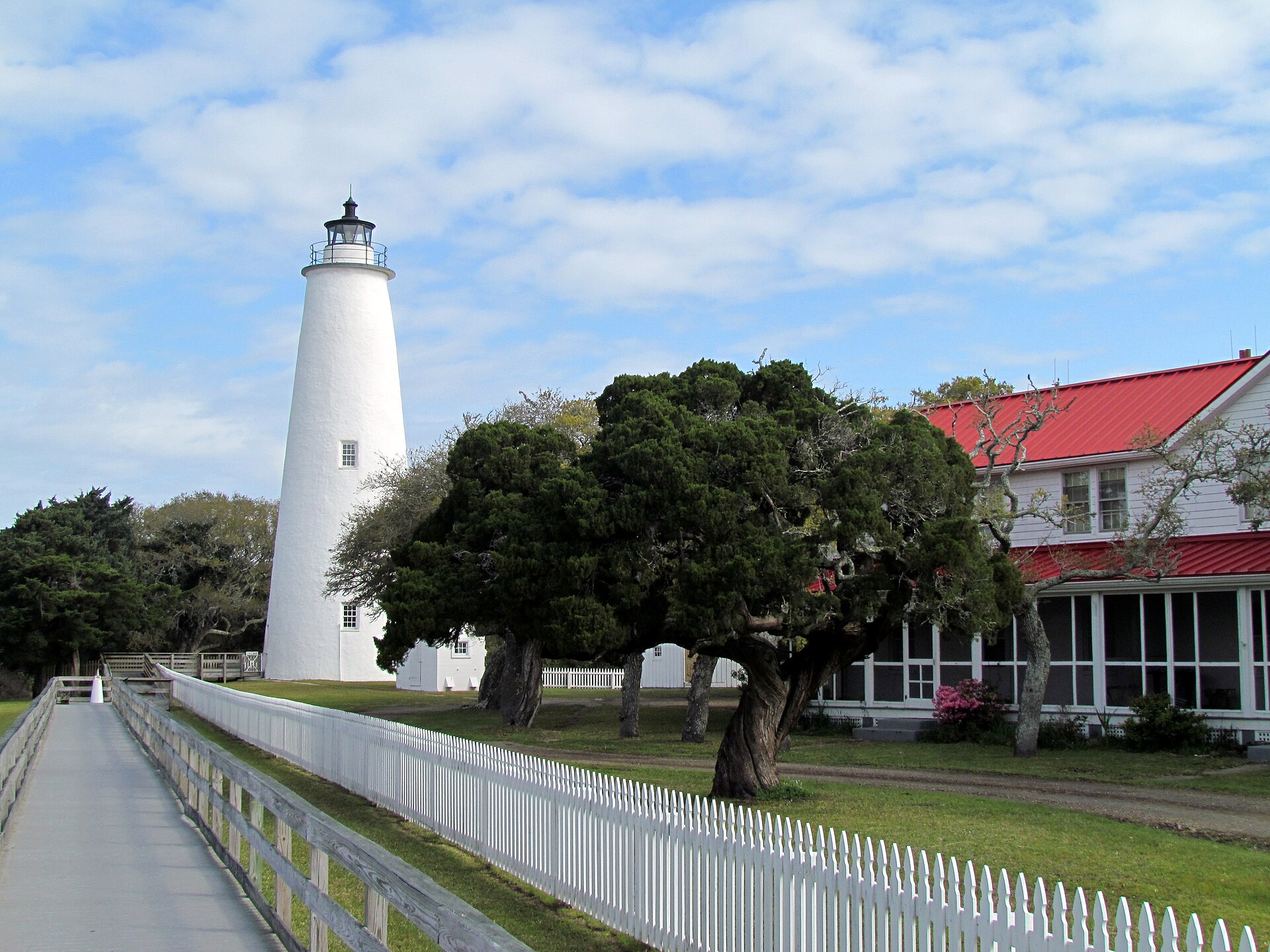
Ocracoke Island is part of the Outer Banks of North Carolina, in Hyde County. No bridges connect it to the mainland—access is by ferry (from Hatteras Island, Cedar Island, or Swan Quarter), private boat, or small plane. The village of Ocracoke sits at the southern end of the island around Silver Lake, a sheltered harbor; most of the island is within Cape Hatteras National Seashore. The name evolved from an Algonquian word that appeared on early maps; the island was not permanently settled until 1750 and was a favorite anchorage of Edward Teach—Blackbeard—who was killed here on November 22, 1718, in a battle with troops from Virginia. Springer's Point Nature Preserve, a short trail through maritime forest to the Pamlico Sound, is said to have been Blackbeard's hideout. Ocracoke Light, near Silver Lake, has been in continuous operation since 1823. The island has a distinct dialect known as the "Hoi Toider" or High Tider accent; locals call non-natives "dingbatters." Tourism and fishing drive the economy; the British Cemetery holds four British sailors who washed ashore after their ship was torpedoed by a German U-boat in World War II—a memorial ceremony is held each May. With dark skies and minimal light pollution, the beaches offer excellent stargazing. Ocracoke remains a hidden gem for those willing to take the ferry.
From Hatteras Island, the free vehicle ferry runs first-come, first-served and takes about one hour; the Ocracoke Express passenger ferry (reservations accepted) docks at Silver Lake in the village in about 70 minutes. Toll ferries from Cedar Island and Swan Quarter take 2.25 to 2.5 hours and 2.5 to 3 hours respectively. North Carolina Highway 12 runs the length of the island from the north ferry terminal to the village. Plan for ferry wait times in peak season and check ncdot.gov for schedules. In the village, rent a golf cart or bike to explore—parking is limited. Walk Springer's Point (less than a mile round trip), visit Ocracoke Light and the British Cemetery, and stop by the wild Ocracoke ponies (Banker ponies descended from shipwrecked horses). Beaches include a lifeguarded stretch; 4×4 beach driving is allowed with a permit (recreation.gov). Restaurants and shops line Silver Lake and the main streets—Eduardo's Taco Stand, Dajio (local seafood), Howard's Pub, 1718 Brewing, and Ocracoke Coffee are popular. The island has an annual fig festival and fig cake contest. Hurricane Dorian (2019) damaged NC 12; check current conditions. Best times to visit are late spring through fall; early September and October offer thinner crowds and warm weather. Visit visitocracokenc.com for lodging, events, and tips.
Ocracoke Island rewards travelers who want a ferry-only escape, pirate history, a laid-back village, and some of the Outer Banks' best beaches and darkest skies.
Marfa
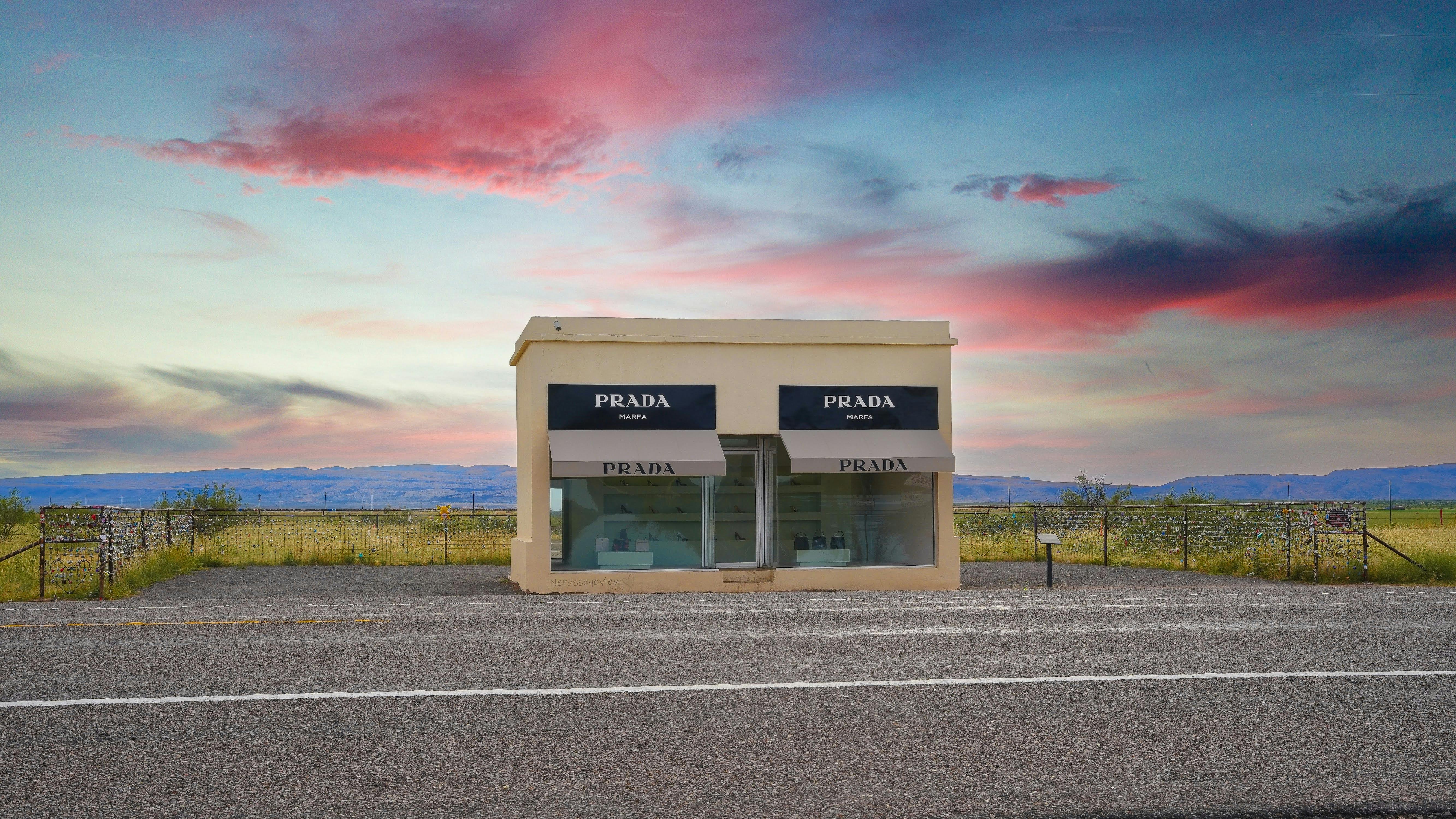
Marfa is a small town in Presidio County in the high desert of West Texas, about 60 miles (97 km) south of the Guadalupe Mountains and roughly 200 miles (320 km) southeast of El Paso. The town was established in the 1880s as a railroad water stop and later became a ranching and military hub; today it is best known as an art destination. In the 1970s the artist Donald Judd moved to Marfa and began installing large-scale minimalist works in repurposed buildings and across the surrounding landscape. The Chinati Foundation, which he founded with the Dia Art Foundation and opened in 1986, now occupies the former Fort D.A. Russell and displays permanent installations by Judd, Dan Flavin, John Chamberlain, and others in dialogue with the vast desert and sky. The town also draws visitors for Prada Marfa—a permanent art installation by Elmgreen & Dragset resembling a Prada boutique on U.S. Route 90, about 37 miles (60 km) northwest of Marfa—and for the Marfa lights, mysterious nocturnal lights that have been reported southeast of town toward the Chinati Mountains since the late 19th century; viewing areas off U.S. 90 east of town are popular at dusk.
Marfa has no commercial airport; the nearest major airports are El Paso (about 3 hours by car) and Midland-Odessa (about 3 hours). Rental cars are the norm. U.S. Route 90 runs through town; State Highway 17 connects to Presidio and the Rio Grande. The Chinati Foundation offers guided tours (reservations recommended); allow a full morning or afternoon. Downtown Marfa has galleries, boutiques, cafés, and restaurants—Planet Marfa, the Capri, and Stellina are among the favorites. The Hotel Paisano, where the cast of Giant stayed during filming in 1955, is a historic base. Marfa is at about 4,688 feet (1,429 m); summers are hot and dry, spring and fall are ideal, and winter can be cold and windy. Ballroom Marfa and other spaces host exhibitions, film, and music. A weekend is enough to see Chinati, Prada Marfa, the lights, and the town; combine with Big Bend or the Davis Mountains for a longer West Texas trip.
Marfa rewards travelers who seek minimalist art, vast desert skies, and a small-town atmosphere that has become one of America's most distinctive cultural stops.
Cumberland Island National Seashore
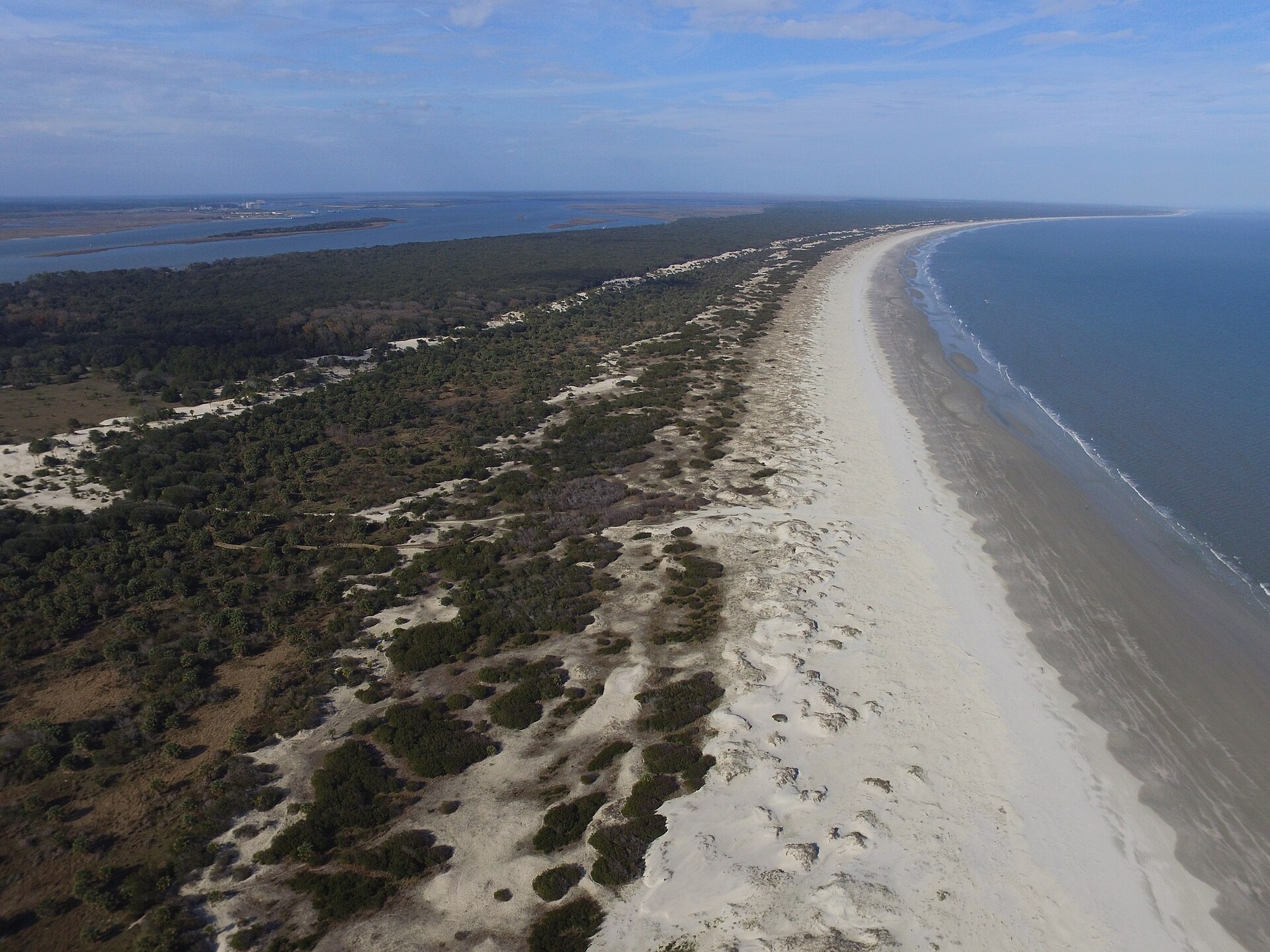
Cumberland Island National Seashore preserves most of Cumberland Island in Camden County, Georgia, the largest of Georgia's Golden Isles. The national seashore was authorized by Congress on October 23, 1972, and is administered by the National Park Service; a 9,886-acre (40 km²) wilderness area was designated in 1982. The seashore features beaches and dunes, marshes, and freshwater lakes and contains at least 23 distinct ecological communities—the largest and most biodiverse of Georgia's barrier islands. The park preserves historic sites: the ruins of the Carnegie family's Dungeness mansion and its gardens, the intact Plum Orchard mansion (1890s), and the High Point Half Moon Bluff Historic District. The Cumberland Island National Seashore Museum in St. Marys, on the mainland, covers the island's history from Timucua Indians to the Carnegie era. Feral horses roam the island. With only about 40,000 visitors per year (2005) and access solely by boat, Cumberland remains a hidden gem for those who book the ferry.
The island is only accessible by boat. The Cumberland Island Visitor Center, Cumberland Island Museum, and the concession ferry to the island are in St. Marys, Georgia—about 45 miles (72 km) north of Jacksonville, Florida. The Cumberland Queen ferry runs multiple times daily in peak season (March to September); from October through February, service is reduced and may run only on weekdays. Reservations are strongly recommended. No vehicles are allowed on the ferry; there are no paved roads on the island. Bikes can be rented at Sea Camp Dock (first-come, first-served) or brought on the ferry for an additional fee. Camping is allowed; the park limits the number of people on the island (typically 300 at a time) and campers to seven nights. Sea Camp has running water and cold showers; other campgrounds are primitive. Bring all food and supplies from the mainland—there are no stores on the island. The Ice House Museum, restored by the NPS near Plum Orchard, displays artifacts from the island's prehistoric, colonial, and Gilded Age history. Guided tours of Plum Orchard are offered seasonally. Spring and fall offer mild weather and fewer bugs; summer is hot and humid with mosquitoes. Check nps.gov/cuis for ferry schedules, camping reservations, and current conditions.
Cumberland Island National Seashore rewards travelers who want wild beaches, historic ruins, maritime forest, and the sense of an island apart—reachable only by ferry and with no cars.
Canyons of the Ancients National Monument
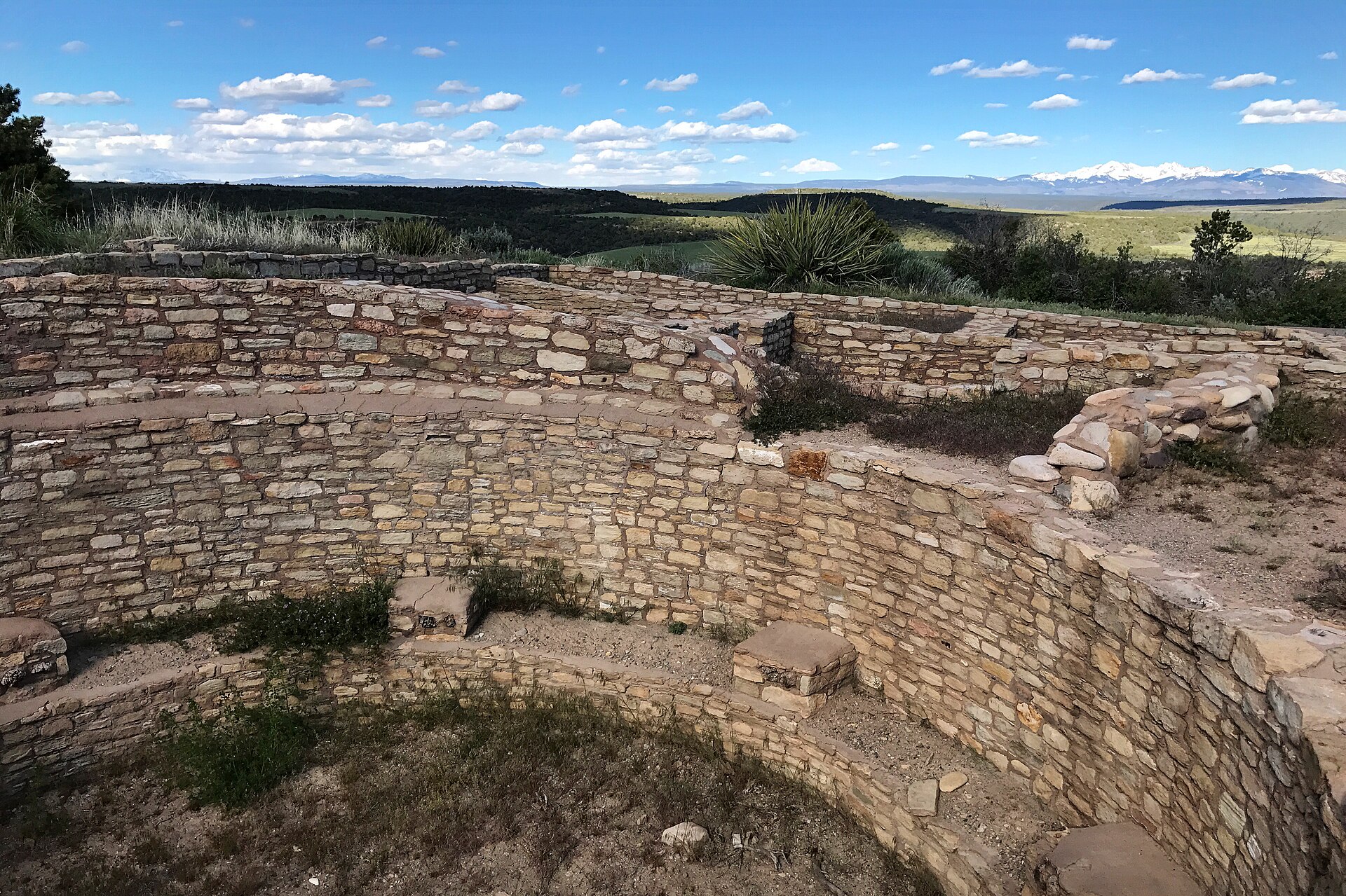
Canyons of the Ancients National Monument is a national monument protecting an archaeologically significant landscape in Montezuma and Dolores counties in southwestern Colorado. The monument's 176,056 acres (712 km²) are managed by the Bureau of Land Management and were proclaimed on June 9, 2000, to preserve the largest concentration of archaeological sites in the United States—over 8,500 documented, primarily Ancestral Puebloan ruins. The monument encompasses or borders three of the four sections of Hovenweep National Monument (NPS). The density of archaeological remains here is the highest of any region in the country: pueblos, kivas, towers, petroglyphs, reservoirs, and check dams span the Developmental Pueblo period (AD 500 to 1100) and the Great Pueblo period (AD 1100 to 1300). Lowry Pueblo, a National Historic Landmark excavated in the 1930s, has 40 rooms, 8 kivas, and a great kiva with layered murals; Painted Hand Pueblo and Sand Canyon Pueblo are among the other notable sites. Unlike monuments that protect only major ruins, Canyons of the Ancients was designed to protect the full landscape where ancient people lived, farmed, and gathered—a hidden gem for anyone interested in Ancestral Puebloan history without the crowds of Mesa Verde.
The nearest city is Cortez, Colorado—about 10 miles (16 km) from the monument and roughly 45 miles (72 km) west of Durango. The Canyons of the Ancients Visitor Center and Museum (formerly the Anasazi Heritage Center) is the main gateway: it holds artifacts from the monument, interactive exhibits on Ancestral Puebloan culture, and information on the Trail of the Ancients Byway and the monument. Lowry Pueblo has parking, a picnic area, toilets, and a short trail; Sand Canyon Pueblo has a trail that leads to McElmo Canyon. Many roads in the monument are unpaved; high clearance or 4WD may be needed for some routes—check conditions at the visitor center. Spring and fall offer mild temperatures; summer can be hot. Do not climb on ruins, remove artifacts, or disturb archaeological sites. Combine a visit with Mesa Verde National Park and Hovenweep National Monument for a full Four Corners archaeology trip. Check blm.gov for the visitor center hours, seasonal access, and current conditions.
Canyons of the Ancients National Monument rewards travelers who want to explore the nation's richest concentration of Ancestral Puebloan sites in a vast, quiet landscape far from the busier parks.
Conclusions
These ten hidden gems of the United States prove that some of America's most spectacular landscapes and singular places lie far from the crowds. Whether you explore the Chihuahuan Desert at Big Bend, walk among the Painted Hills and fossil beds of John Day, discover the volcanoes and steaming vents of Lassen, drive the Wildlife Loop among bison and burros at Custer State Park, hike the High Peaks and paddle the lakes of the Adirondacks, kayak the sea caves and lighthouses of the Apostle Islands, take the ferry to Ocracoke Island for Blackbeard's haunt and Silver Lake, head to Marfa for minimalist art and the Chinati Foundation, take the ferry to Cumberland Island for wild beaches and the ruins of Dungeness, or explore the Ancestral Puebloan ruins and canyons of Canyons of the Ancients, each invites you to slow down and discover why those who make the journey often call them among their favorite places.
Spirit of Traveling Team
Passionate traveler and content creator sharing authentic travel experiences and practical tips for independent explorers.